1930 San Zenón hurricane: Difference between revisions
Category 4 Atlantic hurricane in 1930
The 1930 Dominican Republic hurricane, also known as Hurricane San Zenón, was a small but intense and deadly tropical cyclone that severely impacted areas of the Greater Antilles, particularly the Dominican Republic, where an estimated 2,000 to 8,000 people died. The second of three known tropical cyclones in the 1930 Atlantic hurricane season, the system was first observed on August 29 to the east of the Lesser Antilles, and made landfall in the Dominican Republic at Category 4 strength on the modern Saffir-Simpson Scale. Later, it also struck Cuba and the U.S. states of Florida and North Carolina, with less severe effects.
Meteorological history[edit]

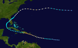
Map key
Tropical depression (≤38 mph, ≤62 km/h) Tropical storm (39–73 mph, 63–118 km/h) Category 1 (74–95 mph, 119–153 km/h) Category 2 (96–110 mph, 154–177 km/h) Category 3 (111–129 mph, 178–208 km/h) Category 4 (130–156 mph, 209–251 km/h) Category 5 (≥157 mph, ≥252 km/h) Unknown
The system is estimated to have formed on August 29 about halfway between the Lesser Antilles and the Cape Verde islands, although there were indications it may have formed closer to the African coast a few days earlier. Moving westward, the system slowly intensified, with its track and path based mainly on continuity. It is estimated to have become a hurricane on August 31 about 385 miles (620 km) east of Guadeloupe.[1] Operationally, the hurricane was first observed on September 1, while the storm was passing through the Lesser Antilles as an intensifying hurricane. Based on north winds in Dominica and south winds in Barbados, the evidence of the circulation prompted an observer to report, “[there are] evidences of an approaching hurricane.” Cautionary advice was immediately sent out from Barbados to Saint Lucia, and based on additional ship and island reports, the National Weather Bureau issued storm warnings for the southern coasts of Puerto Rico and Hispaniola.[2]
After passing over or near Dominica, the hurricane entered the Caribbean Sea with winds of 100 mph (160 km/h), the equivalence of a Category 2 hurricane on the Saffir-Simpson hurricane scale.[2] On September 2, the hurricane passed about 60 mi (97 km) southwest of Puerto Rico as it intensified into a major hurricane. Due to the storm’s small size, winds on the island were below hurricane force. Continuing slowly west-northwestward, the hurricane continued to intensify as it approached the Dominican Republic. Captain Thomas Evans of the SS Coamo of the Porto Rico Line, its crew and passengers all survived being buffeted by the storm for seven hours and passing through the eye. He reported a barometric pressure of 933 mbar (27.6 inHg) and a detailed description of its near capsizing off the coast of the Dominican Republic to The New York Times when they arrived in San Juan on September 4. The New York Times published the story on September 5 as “Steamer Outrides Storm’s Full Fury: Caught in Vortex of Hurricane, Coamo Tilts Periously as Gail Strips Decks”.[3] A steamship just offshore recorded winds of 150 mph (240 km/h), and also provided data to estimate the radius of maximum winds at 8 mi (13 km). At 1800 UTC on September 3, it made landfall near Santo Domingo, Dominican Republic with a minimum central pressure of 933 mbar (27.6 inHg). As it was still intensifying up until landfall, the peak winds were estimated at 155 mph (249 km/h), although it is possible it attained Category 5 status.[1] The worst of the hurricane occurred in a 2-mile (3.2 km) diameter of its landfall location.[2]
The mountainous terrain of Hispaniola rapidly weakened the hurricane, and by about 12 hours after moving ashore the winds decreased to tropical storm status. It quickly emerged into the Windward Passage and moved westward to the south of the Cuban coastline. On September 6 the storm crossed western Cuba before recurving northeastward into the Gulf of Mexico with winds of 40 mph (64 km/h). It strengthened slightly, moving ashore near Tampa, Florida, with 45 mph (72 km/h) winds. While crossing the state, it weakened to tropical depression status, although it re-intensified after moving into the western Atlantic Ocean. By September 12, it again attained hurricane status to the southeast of the Carolinas. After brushing the Outer Banks of North Carolina with winds of 70 mph (110 km/h), the hurricane turned eastward and reached a secondary peak intensity of 100 mph (160 km/h) to the north of Bermuda. It gradually weakened, deteriorating to tropical storm status on September 16 and dissipating the next day to the west of the Azores. The remnants merged with a system that later affected the Azores and Ireland.[1]
Winds of 80 to 100 mph (130 to 160 km/h) were reported on Dominica, with…
Read More: 1930 San Zenón hurricane: Difference between revisions

