

EarthSky | Kentucky flooding crushes records
Kentucky flooding brings death and destruction
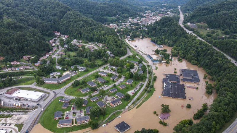
Record-breaking flooding devastated small mountain communities in Kentucky and Virginia today (July 28, 2022) after heavy thunderstorms locked in on the region. Ten to twelve inches of rain fell in just a few hours over very steep terrain. It filled the narrow valleys with rushing water as creeks rose above their banks. First responders rescued dozens of people from the rising floodwaters, but hundreds more remained trapped through the day. As of this writing, officials reported eight deaths. Kentucky’s governor, Andy Beshear, said that he expected double-digit deaths, and emergency services were overwhelmed. Beshear called the event:
One of the worst, most devastating flooding events in Kentucky’s history.
Perry County (population 26,266) and the town of Hazard (population 4,974) were the worst-hit areas. Video on Thursday morning showed that many small towns were wiped completely off the map.
During the day on Thursday, people were rescued from their roofs surrounded by 20-plus feet of water. According to the governor’s office, it is still unknown exactly how many people are still missing or in need of rescue. Landslides and high water are blocking many roads, limiting access to the worst-hit areas.
Floodwaters swept homes off their foundations and transported them downstream. Cars and vehicles piled up against trees miles away from their original locations. Many residents and meteorologists from the region called it complete devastation.
Power of water. #kentuckyFlooding pic.twitter.com/cqwFnl9VWJ
— WxChasing- Brandon Clement (@bclemms) July 28, 2022
Fire and police are overwhelmed. This is a true catastrophe near Hazard, Kentucky. Major flash flooding. Houses and cars floated away, many occupied. Posting only the lowest damage photos out of respect for anyone viewing, as should anyone. Take my word, this is a disaster area. pic.twitter.com/fLknT0Cbid
— Vince Waelti ? (@VinceWaelti) July 28, 2022
Kentucky flood surpasses records
A river gauge along the North Fork Kentucky River in Whitesburg measured a 20-foot water level increase in 10 hours. A weather station recorded the all-time highest water level of 21 feet around 1 pm in Whitesburg, crushing the old record of 14.7 feet set in 1957. The actual river crest may have been higher, but because of a data loss at the station, measurements stopped at the 21-foot mark. Floodwaters completely inundated downtown, forcing residents to seek higher ground. And flooding completely submerged the elementary school for hours.
Catastrophic flooding ongoing in eastern Kentucky this morning. All-time crest records being crushed.
These are small towns in the bottom of narrow, steep valleys. The human toll is unfortunately likely to be high. #kywx #vawx pic.twitter.com/7wdtCsNLD3
— Peter Forister ????? (@forecaster25) July 28, 2022
An eyewitness account
Storm chaser and photographer Billy Bowling was on the scene of the flooding on Thursday afternoon. Bowling is a Virginia native and has seen many floods in this region of the Appalachians. Bowling said that the flooding in Whitesburg:
… touched nearly every building in the city.
He said the water was widespread and deeper than any event he had previously witnessed. Bowling described the scene:
Water enveloped 80% of the buildings in Whitesburg [population 2,215]. Homes by the river were submerged to the very top of the roofs, and the high school was completely underwater to the roof. It was devastation at a scale that I’ve never seen in the region before. Instead of one small town, it was an entire city completely shut off from the world.
Bowling also witnessed several water rescues with people trapped in cars, including one car that emerged only after having been underwater for many hours. Bowling said:
The rescuers didn’t even know it was there. By the time they realized the car was trapped, it had turned into a body recovery.
Whitesburg, Ky. The middle school is nearly under water. Numerous homes with only the crest of roofs showing AFTER the water has receded in the past few hours. These folks need help. #kywx@spann @JimCantore @ReedTimmerAccu @ryanhallyall @nwsjacksonky pic.twitter.com/hCah7gVYsM
— Billy Bowling (@babowling12) July 28, 2022
The devastation that catastrophic flooding leaves behind always leaves me feeling hopeless, but today, I saw a lot of good people running towards Kentucky to help our neighbors.
?Whitesburg, KY pic.twitter.com/5bzmi9iRDb
— Billy Bowling (@babowling12) July 28, 2022
The source of the Kentucky flooding
Torrential thunderstorms developed late on Wednesday night along a stationary front in eastern Kentucky and western Virginia. This frontal system provided a focal point for moisture and lift along the mountains. Deep tropical moisture streamed in from the south and was squeezed out of the atmosphere along the front. Once the storms developed, they remained nearly stationary for 12 hours.
Some weather stations in the Kentucky mesonet, a network of rain-measuring gauges across the state, reported 10.4 inches of total precipitation. However, meteorologists said that rainfall was likely higher in some areas. According to radar estimates, a foot or more of rainfall fell in some places.
Meteorologists at the National Weather Service (NWS) issued Flash Flood Emergencies as the flooding began. These warnings are the most serious that the NWS uses in flooding scenarios. They are reserved for events with catastrophic impacts. When the alerts sounded through the emergency broadcast system, people scrambled to find higher ground. Storm chasers on the scene said that the quick work by the NWS to recognize the situation and issue warnings likely saved many lives.
Storm after storm produced catastrophic flooding in Eastern Kentucky last night.
Extreme rainfall events are more common and more extreme with climate change. pic.twitter.com/O4lz4LJobN
— Dakota Smith (@weatherdak) July 28, 2022
Radar is estimating more than a foot of rain since Monday across areas of southeastern Kentucky. This is absolutely incredible to see. #kywx pic.twitter.com/8dDZu6aZzc
— Chris Bailey (@Kentuckyweather) July 28, 2022
Going into the rain gauge data…
The community of Engle, along Route 15 between Jackson and Hazard, had 1.41″ of rain in 15 minutes (between 12:35-12:50am).
Source:https://t.co/jPYfLeM7Jv
— Sean Sublette (@SeanSublette) July 28, 2022
A dangerous week for flooding in the US
The flooding in Kentucky follows an intense week of heavy rainfall across the country. The same weather system dumped 12 to 14 inches of rainfall in Missouri, leading to widespread damage and water rescues. St. Louis measured a single-day rainfall record in just a few hours. Flash flooding also occurred in Colorado, Arizona and Utah on Thursday. And forecasters call for more flooding in the coming week.
Meteorologists expect heavy rain to continue in Kentucky and far western Virginia on Friday and Saturday. The stubborn frontal system will bring more chances for slow-moving thunderstorms, which could drop an additional two to four inches of rain. The frontal system will also remain through the beginning of August, although forecasts remain uncertain about the exact placement of the heaviest rain.
Bottom line: Record-breaking flooding devastated parts of Kentucky as 10 to 12 inches of rain fell. The Kentucky flooding is one of the most devastating flooding events in the state’s history.
Read More: EarthSky | Kentucky flooding crushes records