

Images and patchy communications reveal devastation in Tonga after tsunami
Wellington — A volcano that exploded on the Pacific island nation of Tonga has almost disappeared from view, new images revealed Tuesday, with swathes of the island nation smothered in grey ash and dust or damaged by a tsunami. Tonga has been virtually cut off from the rest of the world since Saturday’s volcanic blast — one of the largest recorded in decades.
The volcano erupted about 19 miles into the air and deposited ash, gas and acid rain across a large area of the Pacific. Three days after the eruption, the outside world was still scrambling on Tuesday to understand the scale of the disaster, using patchy satellite phone connections, surveillance flights and satellite images.
The human toll remained largely unknown on Tuesday, but New Zealand said at least two people had been confirmed killed, citing Tongan police. One of them was Angela Glover, a 50-year-old British woman who ran an animal rescue charity. Her family said her body was found after she was swept away by the tsunami.

Handout/New Zealand Defense Force/Getty
Satellite images released by Maxar Technologies on Tuesday showed that where most of the volcanic structure stood above sea level a few days ago, there is now just open sea. Only two relatively small volcanic islands were still visible above sea level after the eruption.
“What we saw above the water, that has now been destroyed, was only the tip of a volcano that had grown on the rim of the massive underwater volcano,” said Monash University volcanologist Heather Handley.
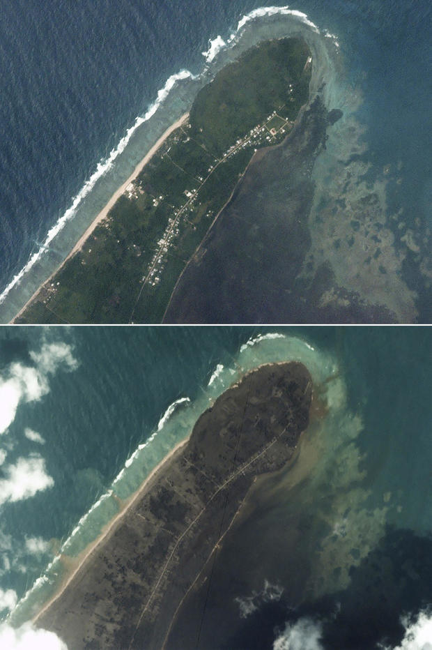
New Zealand released aerial images taken from a surveillance flight the previous day, revealing a tree-lined coast transformed from green to grey by the volcanic fallout. Wrecked buildings were visible on the foreshore alongside others that appeared intact.
Volcanic ash blanketed island fields, images from an Australian Defence Force P-8A Poseidon patrol aircraft showed. Shipping containers had been knocked over like dominoes at a port on the main island.

Handout/New Zealand Defense Force/Getty
Australia’s HMAS Adelaide and New Zealand’s HMNZS Wellington and HMNZS Aotearoa were ordered to be ready for a possible aid request from Tonga, which lies three to five days’ sailing away.
With water sources feared to be poisoned by volcanic fallout, the Red Cross said it was sending 2,516 water containers.
France, which has territories in the South Pacific, pledged to help meet the people of Tonga’s “most urgent needs.”
The United Nations said a signal had been detected from a distress beacon on the low-lying island of Mango.

Japan Meteorology Agency via AP
The U.N. Office for the Coordination of Humanitarian Affairs said surveillance flights had confirmed “substantial property damage” on Mango, home to some 30 people, and another island, Fonoifua. Later on Tuesday the Reuters news agency quoted Tongan government officials as saying every single home on Mango had been destroyed, and only two remained standing on Fonoifua. The officials said fresh water supplies across Tonga were contaminated with ash.
The U.N. agency also reported “extensive damage” on the western beaches of the main island Tongatapu, “with several resorts and/or houses destroyed and/or badly damaged.”
Tonga’s capital Nuku’alofa was shrouded in almost two inches of volcanic ash and dust, it said. Power had been restored to parts of the capital. Local phone systems had been restored but international communications were still difficult as the blast severed an undersea communications cable between Tonga and Fiji. Operators said it would take up to two weeks to repair the cable.
Planet Labs PBC via AP
The capital’s waterfront, the U.N. body said, was “seriously damaged with rocks and debris pushed inland from the tsunami.”
Satellite images released by the United Nations Satellite Center…
Read More: Images and patchy communications reveal devastation in Tonga after tsunami