

Tonga volcano: What to know about the eruption and tsunami
Australia’s meteorological service said a “large eruption” took place at the Hunga Tonga-Hunga Ha’apai volcano on Monday, but no tsunami warnings have been issued.
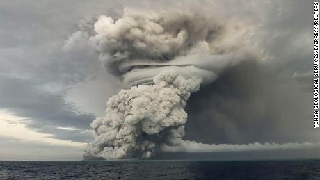
Saturday’s eruption was likely the biggest recorded anywhere on the planet in more than 30 years, according to experts. Dramatic images from space captured the eruption in real time, as a huge plume of ash, gas and steam was spewed up to 20 kilometers (12.4 miles) into the atmosphere — and tsunami waves were sent crashing across the Pacific
No mass casualties have yet been reported, but aid organizations are concerned about contaminated air and access to clean water for people in Tonga’s outlying islands.
With communications down, Australia and New Zealand sent flights to survey the damage.
Here’s what we know about the eruption and fallout.
Where is Tonga’s Hunga-Tonga-Hunga-Ha’apai volcano?
Tonga is a Polynesian country of more than 170 South Pacific islands and home to about 100,000 people. It’s a remote archipelago that lies about 800 kilometers (500 miles) east of Fiji and 2,380 kilometers (1,500 miles) from New Zealand.
The Hunga-Tonga-Hunga-Ha’apai volcano, about 30 kilometers (20 miles) southeast of Tonga’s Fonuafo’ou island, sits underwater between two small islands at about 2,000 meters (6,500 feet) high from the sea floor, with about 100 meters (328 feet) visible above sea level.
Researchers said it has erupted regularly over the past few decades.
The most recent eruption began in December 2021, with gas, steam, and ash plumes rising about 12 kilometers (7.5 miles) into the air. The volcano erupted again on January 14 and a massive eruption on January 15 sent shockwaves around the world and triggered tsunami waves across the Pacific.
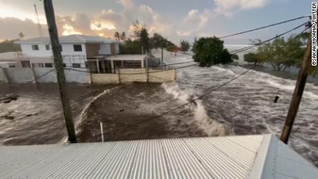
Where did the tsunami hit?
The eruption caused a tsunami on Tonga’s largest island, Tongatapu, with waves recorded at 1.2 meters (about 4 feet) near Nuku’alofa city flowing onto coastal roads and flooding properties on Saturday.
Tsunami warnings went into effect across Pacific Island nations including Fiji, Samoa and Vanuatu. Footage from the ground in Fiji shows people fleeing to higher ground in the capital, Suva, as large waves hit the coast.
Tsunami warnings and advisories were also issued from parts of New Zealand, Japan and Peru, to the United States and Canada’s British Columbia.
In Japan, the northeastern prefecture of Iwate saw waves as high as 2.7 meters (9 feet) and multiple smaller tsunamis were reported in numerous other locations, according to public broadcaster NHK. By Sunday afternoon, all tsunami advisories had been lifted in Japan.
The eruption also sent waves to the US West Coast, with some exceeding 3 and 4 feet in height, according to the National Weather Service office in San Diego. Tsunami waves were felt in California, Alaska and Hawaii.
What is happening with the ash cloud?
A giant volcanic ash cloud blanketed Tonga over the weekend, turning the afternoon sky dark and coating Nuku’alofa in a thick foam of volcanic dust on Saturday.
Save the Children said drinking water supplies could be contaminated by the ash and smoke and the immediate concern in Tonga is for air and water safety.
The ash cloud was drifting westwards and was visible over Fiji, Vanuatu and New Caledonia on Sunday. By Monday it had reached Australia’s Queensland, according to the state’s meteorological service.
“If you noticed a particularly stunning sunrise, it was the sunlight being scattered by #Volcanic ash from the eruption over in #Tonga,” Queensland’s Bureau of Meteorology said on Twitter.
The ash prevented an Australian reconnaissance flight from departing to assess the damage in the early hours of January 17, though the flight did take off later that morning.
Several flights from Australia, New Zealand and Fiji to Tonga were postponed due to the ash cloud.
Early data suggests the volcanic eruption was the biggest since the 1991 blast at Mount Pinatubo in the Philippines, New Zealand-based volcanologist Shane Cronin told Radio New Zealand.
“This is an eruption best witnessed from space,” Cronin said, according to Reuters.
“The large and explosive lateral spread of the eruption suggests that it was probably the biggest one since about the 1991 eruption of Pinatubo,” Cronin said.
What is the scale of devastation?
There have been no reports so far of mass casualties in Tonga and the extent of the damage remains unknown…
Read More: Tonga volcano: What to know about the eruption and tsunami